Grand Canyon SUV Trails, Volume I – The South Rim Country (ongoing field work)
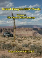 Grand Canyon SUV Trails, Volume I – The South Rim Countrywill describe rough road adventures out of Kingman, Peach Springs, Seligman, Ash Fork, Williams, Flagstaff, Grand Canyon Village, Desert View, and Cameron. Of course, authors Roger and Loris Mitchell will describe the flora, fauna, geology, and history encountered along the way. The book will be well illustrated with many old photographs. The jeep trails described are rated from easy to difficult, but most within the capability of most modern 4-wheel drive SUVs and pickups. Each trail described will include detailed route descriptions and maps, GPS coordinates and a degree of difficulty rating.
SUV Trails Along the Lower Colorado River, Volumes I & II (ongoing field work)
 SUV Trails Along the Lower Colorado River, Volumes I and II – These two books will describe rough road adventures within an hour of the Colorado River. We describe trails out of Boulder City, Searchlight, Bullhead City, Lake Havasu City, Needles, Parker, Blythe, Quartzite and Yuma. Of course, authors Roger and Loris Mitchell will describe the flora, fauna, geology, and history encountered along the way. The books will be well illustrated with many historic photographs. The jeep trails described are rated from easy to difficult, but most within the capability of most modern 4-wheel drive SUVs and pickups. Each trail described will include detailed route descriptions and maps, GPS coordinates and a degree of difficulty rating. Currently, the projected release date for Volume I is late 2014 or early 2015.
Exploring the Sonora Pass Road (ongoing field work)
 Exploring the Sonora Pass Road is the second book in our Sierra Nevada Adventures series. These guides are geared for the average motorist driving the family automobile. In this volume, we will look at the history and high country scenery encountered along California’s State Route 108. This 131-mile-long ribbon of asphalt begins in Modesto in the Central Valley, and ends at its junction with U.S. Highway 395 in the West Walker River country of Mono County to the north of Bridgeport. We will follow the highway east, into the foothills of the Mother Lode country around Sonora, where optional side trips take the motorist into once booming gold camps and lumber towns. The scenery becomes awesome as the highway gradually ascends the western slopes of the Sierra Nevada. Unlike the bare granite domes of Yosemite, just to the south, the Dardanelles country was sculpted by fire and ice. Lava and glaciers caused the rocks to erode into very different landforms. Although 9,674’ Sonora Pass is still closed during the winter months, its history goes back to 1841 when the Bidwell-Bartleson Party of emigrants was the very first to blaze a path anywhere across the rugged Sierra Nevada. The Mitchells will tell the story of their amazing trek. Once you drive over the pass, there are stunning vistas to the east, as the highway descends rapidly, passing pretty roadside meadows before reaching the West Walker River and Highway 395.

These new books look great! Have fun exploring and writing them. I will buy as soon as they are available!
Love your other books they have been wonderful guides and companions on many socal excursions for me.
🙂
Regards,
Clifford
Looking forward to the Sonora Pass Road book. We’ve been enjoying getting glimpses of the old Sonora-Mono Wagon Road on our frequent trips down 108 & look forward to reading more about the Bartelson-Bidwell Party & their route over the mountains. Have been enjoying using your books for many years of great adventures starting with your La Siesta Press Jeep Trail booklets. Hubby is into geocaching & planted a cache at the old limekiln we read about in your Inyo-Mono SUV Trails Bodie & Benton Railway excursion.
Thank you for many great adventures in out of the way but beautiful & interesting places. Very much appreciate your background in geology, which adds so much to our enjoyment.